onsdag 12 maj 2010

Scandinavian Blogger Meetup 2010

The 27 of May I'm off to Vålådalen again for a 3-day hike.  The The Scandinavian Outdoor Blogger meetup will take place there and I wil hike together with some other bloggers who also have an interest in lightweight backpacking and wood burning stoves. The preparations are now well underway and the packlists are getting ready. It will be really interesting to share our experiences. I will have lots of opportunities to try out some new gear, notably the Super Ultralight Gossamer Gear Murmur pack which looks very promising. More posts with discussions on gear choices will follow shortly.

The slope of Trondfjället in autumn colours. Chances are that there will still be quite a lot of snow on the hilltops at the end of may.

tisdag 27 april 2010

A lightweight solo trip to Vålådalen

On September 18, 2009 I went on a solo trip hiking trip to Vålådalen nature reserve in the north of Sweden. I have previously written a short post on the trip, but this was mostly to show the pictures. As I will soon be going there again with some blogger colleagues I thought I will would everyones appetite a bit before the hiking season starts.
A big advantage with Vålådalen, and most of the other mountain areas in Jämtland for that matter, is that it is easy to reach from Stockholm. There are very good train (and flight) connections to Östersund and then on to other destinations (with connecting transports) to the nearby destinations like Vålådalen, Storulvån and Åre. This means you can quite easily arrange for a 3 day trip and still only take one day off from work. Fortunately for me I also happen to have a friend in Östersund who very hospitably not only put me up for the night in Östersund, but also lent me his car during the weekend. I took the X2000 express train from Stockholm at around 16H and at 21H I was in Östersund after a comfortable journey. The next morning I took the car and drove 1,5 hours to Vålådalen. At around 10H I was on the trail (somewhat delayed by a work related call. I'm glad there is no cellphone coverage in the wilderness.).
The route
One of my main goals of the trip was to practice landscape photography. This meant I wanted to climb at least one high point to get some good views. I also wanted to walk as much as much as possible off trail. After reading Tore Abrahamsson's excellent book, "Okända fjäll" ("Unknown mountains"(in Sweden)), I knew that Storådörren and Lillådörren provided some nice scenery so I choose to set my sights on the peak Saalvantjahke which overlook these valleys. On the way there from Vålådalen mountain station I would also pass the Pyramids, Issjödalen and Lunndörrsstugan (a hut). From Saalvantjahke I would slowly get my way back to the trail and continue past Vålåstugorna (also a hut) and then back home to the Vålådalen mountain station. The total distance of this route was around 60-70km. A bit on the far side perhaps, but this was my only chance of hiking this year, so I wanted to make the most of it. Most of the trip was on trail, but that was the price a I had to pay in order to be able to get so far into the area.

Through the forest
The first part of the trip was the most uninteresting as it passes through old forest and you don't get many views. The weather wasn't too good either with a light rain and an overcast sky. I met two women who commented that the ground was very soggy. Funnily enough I hadn't even noticed that, despite the fact that I was wearing trailrunners and thin trousers that get wet in an instant. The forest is still nice though since it is old and untouched. You also pass close to some nice moors.
A dead pine tree on a moss 

Almost at the end of the forest I reached the Saami camp of Grönvallen. Here I met a nice swiss couple who where out for a day-hike. I decided to have lunch here, although it was a bit early. It's always nice to have company, and at Grönvallen there is also lean-to with already prepared dry wood which made the Bushbuddy cooking a breeze (This is definitely cheating though.).


A atream near Issjödalen

About two kilometers after Vålådalen the scenery starts to open up a bit more when you enter the gorgeous Ice lake valley. Luckily the weather also improved at this stage. This valley was shaped by water during the ice age. This is true of almost all places in Sweden, but here it so visible since an old river of meltwater has left a nice moraine. You can clearly see how the water was running if you look at satellite photos.

Issjödalen - The Ice lake valley

Another interesting formation, also clearly visible in Google Maps, are the "Dead Ice Pits". These are pits formed by leftover ice in the sand. From above the terrain looks almost like a moon landscape with craters.

A dead ice pit in front of the kings hunting lodge

The Swedish king also has hunting cabin here. Ptarmigan hunting is very popular in this area. This year however there was no hunting, since there were not enough birds due to a very cold spring and otherwise poor conditions. The amount of Ptarmigans is mostly dependent on the temperature during spring and the amounts of rodents available, not hunting. Rodents, mostly Lemmings, are the staple food of the Ptarmigans predators: birds of prey and foxes. If the predators can't find enough rodents, they will eat Ptarmigans instead. Luckily, despite the scarcity, I saw six Ptarmigans on the trip.
After the Ice lake valley I wanted to see the famous "Pyramids". These formations are also creations of the great ice cover.

The pyramids

The path to the pyramids was a very pleasant plateau overlooking the valley. It felt great to be on the mountain, especially since the sun started to appear here and there.
After this plateau the trail towards Lunndörrsstugorna follows a nice ravine. Which I failed to get a nice shot of. Why didn't I take the time to get a good shot? That stupid branch is really annoying. I was probably in too much of a hurry to reach the sauna in time.

The ravine between the pyramids and Lunndörssstugan

Not far from the mountain hut a flock of migrating geese flew by. It was the end of the season for them too. Not long after I arrived at the hut and decided that the lake and the sauna were definitely worth a visit. A bit too luxurious, but the place just looked to inviting.

The lake at Lunndörrsstugan in the evening sun

After the sauna it was time for dinner. Despite the rain during the day, it was no problem to find suitable dead twigs for the dinner fire.

The Bushbuddy with all the fuel needed for dinner

The evening sun made scenery even more beautiful. I had never been to the mountains in fall before. I had heard that the colours are nice, but I hadn't imagined it could be this good. This nice time slowed me down however and when I started on the trail again I noticed I was behind schedule. It's seldom a good idea to look for a good campsite when it's dark. My initial plan was also to set up camp near the treeline at Tväråkåtan and it was now clear I would not have time to reach that spot.

Getting dark and still some way to go

Luckily I did not have too much difficulty in finding a site and soon my Six Moon Designs Lunar Duo was up and the Bushbuddy was put to work again to make me some hot blueberry soup. It's always nice to get a hot drink and some extra energy in the body before going to bed. The evening was a bit on the chilly side and there was also a slight cold breeze. The Lunar Duo is a single skin tent and as such it is a bit colder than a double skin. I had decided to pitch the tent pretty high to avoid condensation, but in hindsight I should perhaps have pitched lower to avoid some of the cold airflow through the tent. I could also have used the bivy bag I had with me. I slept fairly well anyway though. But I could not say I was completely warm all the time.

Six Moon Designs Lunar Duo set up for the night

When the morning came I made breakfast consisting of oatmeal, minced hazelnuts and blueberry soup. I had a small plastic bag with the mix already prepared for each breakfast. Having devoured this hearty meal I was ready for the climb up to Saalvantjahke. I was now completely off-trail and I enjoyed every minute. Finally I was making my own way. My chosen route on unknown ground, as the motto is for orienteering in Sweden. I was afraid that solo hiking would be boring, but I found that there was always something interesting to think about. How is the weather going to develop? Where will I put up the tent? What's the best way up the slope? What was that sound, etc etc. Near Tväråkåtan I saw the remnants of an old Saami Lavvu (Teepee) site.

Stone ring from the firepit of a Lavvu

Near this place I also caught a short glimpse of a female elk. It ran away as all the other elks would later do this hunting season. Soon I was above the tree line and the views started to open up.

Mountain birch

As I was approaching the top I started to think about finding fuel for a lunch break. Now was a particularly good time to practice Bushbuddy cooking in alpine surroundings (Well, a bit too easy really since there was no wind and rain.). At first glance it did not look very promising. Very little vegetation was to be found.
Above the tree line on Saalvantjahke facing west

A closer look however revealed an abundance of dry wood. The ground here is also so well drained that these crowberry roots dry very quickly. I only needed a few minutes to gather enough fuel. In rainy conditions things could be more difficult and you need to search for branches that have been sheltered from the rain.
Dry crowberry roots - Excellent and abundant fuel

Now it was time for a photo session. The view from Saalvantjahke was every bit as good as I had hoped. Both the Lillådörren valley and the Storådörren pass where well in view. Luckily for me the sun had also chased a way most of the clouds.
Lillådörren

Storådörren

Unfortunately I had forgotten to fill my waterbottles, fuel might have been abundant, but water not, so the lunchbreak was transformed into a less substantial snack break consisting of blueberry soup. It turned out I was not the only one to have enjoyed this spot for eating. Some bird of prey, likely a buzzard, had left parts of a Ptarmigan here. On my way down I was lucky to actually see four live birds (Ptarmigans).

A Ptarmigan foot

Going down from Saalvantjahke you could say that I reached the peak of scenic satisfaction. The valley with the Tronnan-stream was just too beautiful; the colors, the calm, the wilderness, the warm weather, at this point I even needed to curl up the arms of my shirt. I needed to take a break again in order not be afflicted with the hillwalkers equivalent of the Stendhal syndrome.

Resting among blueberries

After having rested comfortably on my Jysk foam pad on the heather and feasted on the ripe blueberries I gently strolled down to the stream and started to think about the upcoming ford. The water was very shallow so fording was a piece of cake. My feet got wet of course, but after five minutes I had forgotten about that. Some walkers put on gore-tex socks or SealSkins before fording, but I must say I find that completely unnecessary as long as the temperature is not too far below 5C or so. When walking my feet get warm so fast anyway.

The Tronnan stream

A few kilometers downstream I started to get hungry again and it was time for a proper lunch. I brought commercial freeze-dried food of different variaties on this trip for all major meals. I cannot say I was happy with any of the bags though. They were all edible, but all of them had some artificial flavor. The next time I will try to prepare my own dried food. The meal was made a lot better by the company though. A flock of reindeer joined me for the meal. A trip to the Scandinavian mountains is never fully complete without a reindeer encounter.

Reindeer as lunch company

My last few kilometers of off-trail travel provided for more photo opportunities. It's no wonder that many artists like to paint pictures of the mountains in the fall.

A good motive for Helmer Osslund?

Having passed through the Helmer Osslund painting I soon arrived on the marked trail again. It was with somewhat mixed feelings. On the one hand I was happy to have navigated correctly, but it also meant that due to time constraints the rest of the trip would now be almost exclusively on well-beaten paths. One day of bushwacking in the wilderness was all I would get this year.

The bridge over Vålån

Now there was not too much time to stroll around anymore. I needed to keep up the pace in order to have some safety margin for the next day. I put the long leg ahead of the short one as we say. When I arrived at Vålåstugorna I was actually a bit tired. Although going off-trail is more enjoyable, it also a lot more taxing. Especially when you gain and lose altitude.

Vålåstugan mountain hut

At Vålåstugorna I had a short rest and stocked up on some fruit soup. The rest stop would be short however, and I got some exercise of another kind here as I was kindly asked if I could chop some firewood for the winter.
Now it was getting a bit late, but I anyway wanted to push on a few kilometers more. I set my sights for the slope of Smällhögarna which seemed to provide a nice scenic campsite. On the way up I was lucky again and saw another flock of Ptarmigans which took off just a few meters from my feet.

Campsite above Kroktjärnarna

I wanted to camp high to try out my new tent a bit. There was not much wind to talk about, but still enough to get the fly to flap around. The Lunar Duo takes a bit more time to set up correctly compared to a tunnel- or dometent. I think the weight savings is definitely worth it in the summer though. 1,3kg for a roomy two person tent is not much. This time I pitched the tent with the fly all the way down to the ground to avoid draft. This was probably a wise choice as I felt warmer during the night and the small breeze removed almost all condensation anyway.

Even though I was toasty in my sleeping bag, I did not feel all well anyway. A flu had started to set in. I couldn't really sleep well. The upside of this was that I didn't oversleep the sunrise. I had the longest photo session during the trip and had some fun playing with different exposure settings.

Sunrise

In the morning I packed up and set out in the ultralight style without a real breakfast. This way the hike quickly got my body warm and when I sat down for breakfast a kilometer later I could enjoy the meal better.

Breakfast

The rest of the hike was pretty uneventful and I just hiked as fast as I could in order to have plenty of time to relax at the mountain station in Vålådalen. It was a real pleasure to have a hot shower after all the hiking. After eating lunch in the restaurant I was back in the car towards Östersund. As happy and content as a man can be.

fredag 19 februari 2010

Building a cheap, lightweight, Paris-skipulk

In january the entire family went on skiing vacation to Orsa Grönklitt in Dalarna, Sweden. From experience I knew that transporting the children back and forth to the slopes can be a real chore. Especially when the children are tired after a long day. Having a pulk to pull all the equipment can be a real help. It's also real nice to be able to put the small children in the ski pulk when they decide they've had enough of cross-country skiing several kilometers from home. Last, but not least, I of course saw this as a chance to get an interesting new piece of gear.
Since I don't get a chance to use a skipulk that often I didn't want to spend too much money on it. I don't have as a goal to go on a long arctic expedition with 100kg either, so I figured I didn't really need the robustness of a Fjellpulken. I also had a look at the second-hand market. It is pretty good for pulks here. If you are not worried about weight it is quite easy to find old used Segebaden wooden pulks of good quality. These weigh quite a lot though and they require some care to maintain. There had to be a better alternative.

The Paris Expedition sled
After some googling I found the most authoritative site on skipulks: www.skipulk.com. The nice thing about this site is that they provide an excellent ski pulk PDF-book with detailed descriptions on how to build your own ski pulk. This book, and many others sites, recommend the Paris Expedition sled as a good starting point for a do-it-yourself project. The Paris sled is cheap (around 30€), light (2,2kg) and very durable. It also has good attachment points for packing straps and ropes for pulling. I quickly ordered one from globetrotter.de as there were none in stock at the local retailer kgoutdoor.se.
The Paris Expedition Sled

The hauling system
The pulk book contains a number of different designs for the critical pulk hauling system ranging from very simple designs suitable for flat terrain, to heavy duty systems for alpine use. I didn't have much time for the construction so I made a hauling system loosely based on the "Zinsard"-design. I figured it would be good enough for my purposes. I was not going to use the pulk on rough and steep terrain. It would be used mainly on prepared cross-country tracks.
The hauling system was made from 20mm electrical wire conduit (VP-rör)

The advantage of using plastic conduit is that it is very easy to work with. It is also cheap and you can get angle parts and joints to easily create constructions. It is also very flexible will not hurt you if you fall. The opinions vary on how robust the conduits are, some say they are better than bamboo, some say they are very fragile. For my purposes they worked well. To be on the safe side however, I also reinforced the poles with duct-tape, so that they would not splinter in a dangerous way if they broke. This probably makes them stronger too. The poles where attached to the the pulk by using packstraps through the grommets on the pulk. 
Using conduit joints, the poles can be disassembled for easier transportation

I also added joints so that the poles could be transported more easily. This was done using standard plastic joints for conduit. To keep them in place I also drilled a hole for a nut and a bolt. Later on I also drilled a hole so that the hauling rope went through the poles and all the pull forces where taken by the rope. This is quite useful since the joints don't need to be as strong then. If the poles will break it is also always possible to pull the pulk using the rope.

 A custom hipbelt was quickly sewn

I didn't have any existing hipbelt to use as a harness available, so I sewed my own. It was done in about an hour using nylon, some foam pad, and webbing. I made a mistake however and made the belt to short. It needs to have more padding on the stomach side as well. As attachment points I sewed in some metal D-rings. I did not place these in a good way however. They should be more on the sides so that the poles attach to the side of the body. To attach the poles to the belt I drilled a hole through the poles and threaded to loops of nylon cord through them. These loops could then be attached to the D-rings. This attachment system worked OK, but there is room for improvement. There was too much play between the poles and the hipbelt. Despite these shortcomings the belt worked perfectly OK for the loads that I was pulling.

Field testing
The pulk was mainly used to transport the kids back and home to the slopes. However, I also stressed the hauling system to some degree as I climbed the downhill slope all the way to the top and successfully skied down on a pretty steep slope with around 20kg of young son in the pulk. It worked very well, but I'm not sure how the poles would have handled a fall. I also tried going through the kids "Bumpy ride" training slope as well. On these occasions I could really feel the force of the pulk pushing me in the back, but it worked.
Going down the slalom slope at full speed with Simon lying in the pulk

One situation that didn't go so well however was if I needed to pull the pulk through difficult terrain. Part  of the difficulty could have been that the children were sitting up and produced a top heavy load. Anyway I felt that stronger poles could have been good in that situation. With two kids the pulk was pretty heavy then, probably about 45kg.

All in all, I'm very pleased with the Paris Pulk and the homemade hauling system also worked very well for what it was designed for. It made our winter vacation with the kids so much more fun and a lot easier too.
Children sleeping in the pulk after a long day at the Orsa Grönklitt Zoo

onsdag 27 januari 2010

On Marcus Aurelius and tools for armchair trekking

.
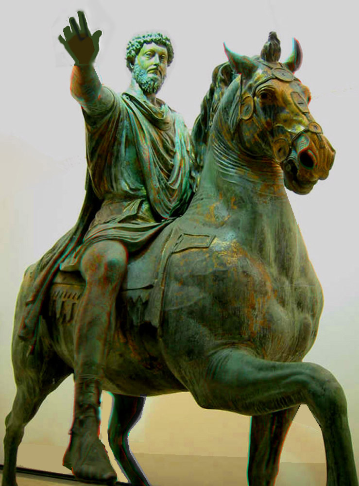
Picture linked from : academic.shu.edu/honors/1101.html

Ever since watching the movie Gladiator, where Marcus Aurelius is depicted  briefly in the beginning, I have been interested in reading more about this Roman emperor. A while ago I finally got around to actually read the texts from the emperor himself, the Meditations. When reading letters from ancient people it is often striking how similar their problems are to ours. Funnily enough, Marcus Aurelius even has some consoling words for a longing armchair trekker like myself.

"People try to get away from it all - to the country , to the beach, to the mountains. You always wish you could too. Which is idiotic: You can get away from it anytime you like.
By going within.
Nowhere you can go is more peaceful - more free of interruptions - than your own soul."

Marcus Aurelius, Meditations, Book four (Translation by Gregory Hays, The Modern Library Classics, 2002)

With two small children, and a third one to arrive soon, I suspect this kind of mental escape will have to comfort me even more in the future. Books and maps certainly help in providing fuel for the journey, but nowadays with Internet applications we can get even closer to the destinations of our dreams.
When doing the research for my increasingly utopian Sarek project route, I used Google Maps, Google Earth and  the  3D maps of  Hitta.se . The quality of the 3D maps (especially Hitta.se) is often amazing.  It's  almost like flying over Sarek in a helicopter. To complement these views of my imagined route, I got extra information from people on the Swedish outdoor forum, Utsidan.se. One kind member, Pär Lindh, even sent me a link to a picture he took of the exact ascent from Sitojaure to Vassjavaggi I was thinking about (I feared that it would be too steep , but from the picture it seems quite OK). It would be interesting to hear from you, dear reader,  what tools you use for armchair trekking.

söndag 8 november 2009

Everyday exercise with kids

I think I've found a way to exercise. Cycling with two kids in the trailer sure was exhausting. The kids liked it too.
Posted by Picasa

lördag 7 november 2009

Sarek on the run in a week - Route planning

In a previous post I outlined an idea for hiking fast and light in order to see the Rapa valley in Sarek national park in under a week. It is still very much an open question if I will find the time for such a trip the nearest years, but planning for it is a pleasure in itself. If I can inspire anyone to do a reconnaissance trip before me that would also be great. One of the most important aspects of the trip is the route planning. For this purpose I have put up a google map and will now discuss some of the choices.

Start point
There are basically two starting points for getting into Sarek and the Rapa valley by public transport: Saltoloukta and Kvikkjokk. I'm leaning towards Saltoloukta as the trail from Saltoloukta to Sitojaure is mostly flat and the scenery is nice, whereas the trail from Kvikkjokk to the Pårte-hut is mostly in the forest.

The midpoint goal
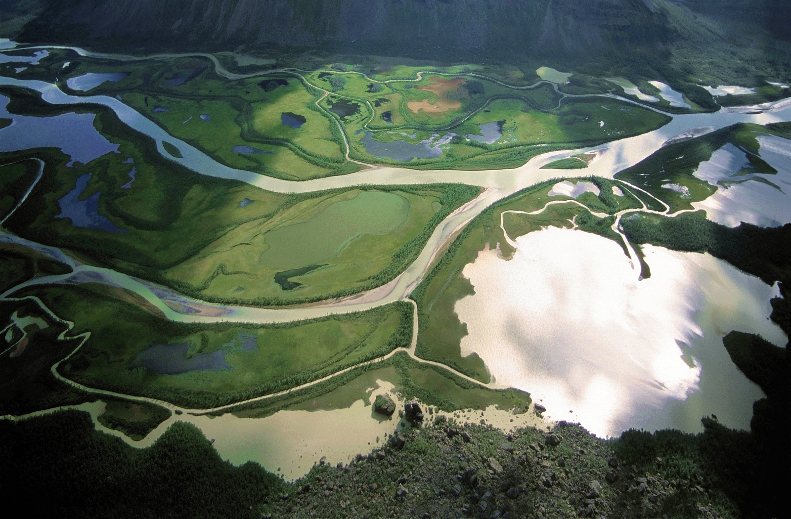
My goal is to see "Rapaselet" (A "Sel" is a stretch of calm water between streams.) and the Rapa-delta. These places are reputed to be among the most beautiful places in Sweden (Even in the world, many would argue.).


The Rapa-delta near Aktse (Source: Creative Commons, M, kluber fotografie)


The Rapa-sel (Source: Creative Commons, photographer unknown.)

The best point for views of the delta is most probably the Skierffe-cliff. From where to view the Rapa-sel is a more difficult question, it depends a bit on how far one can go, but a first stop could be Hill 1112. If one has a bit more time the best place to camp according to the mountain-god, Claes Grundsten, is above the "reindeer-herder hut" on Vassjalåpptå.

Walking plan
If one wants to use a really ultralight shelter, which I want, campsite selection becomes more important. It should not be too exposed to the wind. A site among in the birch-forest is preferable if the weather is windy. This can be difficult to arrange for this trip though.

Day 1: Saltoloukta - Sitojaure. Good camping can be found next to the hut. 20km from Saltoloukta is probably far enough for the first evening, even when runnning. Most probably it will be too late to get across Sitojaure this day.

Day 2: Sitojaure -(By boat) -  Svine - Skierffe - Vassjalåpptå. This will be one hell of a day. The distance will probably be around 24km and this mostly bushwacking in unknown terrain. From my personal experience I often do not tend to walk faster than 2km/h in such circumstances. This translates into 12 hours of walking. Running will most likely be difficult on this stretch. During summer it doesn't really get that dark though, so you can walk well into the night.

Day 3: Vassjalåpptå - Skierffe. 12km. A cool day for taking in the sights.

Day 4: Skierffe - Svine - Saltoloukta. A 31km day, but this time on well-beaten paths.

Day 5. Reserved for unexpected (mis)happenings.

Day 6 Travel home.

An alternative on day 2 is to arrange for the boat to drop you off approximately 3km east of Rinim, instead of Svine (Thanks again to Claes Grundsten for this personal tip). This will reduce the distance to around 12km, but the climb up from Sitojaure to Vassjavagge will be steep. At it's steepest it will be about 500m in a km. It would be nice to hear if anyone has any more experience of this area. This choice will also allow for taking a different route on the way back to Svine.


Calle enjoying the fantastic scenery during the boat-trip back from Rinim to the Sitojaure hut. In the background you see Namadis which is hiding the entrance to Basstavagge where we came from.

måndag 2 november 2009

Sarek on the run in a week - A crazy idea?

Five years ago I hiked in Sarek, Lapland. It was a fantatastic experience. I would love to go there again, but it is very difficult for me to get away for a longer period and it takes quite a lot of time (Approximately 2 days) just to get into the national park. After having switched to lightweight equipment I have however regained the hope of getting there again. A crazy idea was born: I should be able to hike so fast that I could reach the Rapa-valley and get back in under a week. I MUST see the Rapa-valley before I die.

Kungsleden with Lulep Gierkau in the background. Still at least a day from Sarek national park. The trail is like a highway and running should not be a problem at least to Sitojaure.


Fording a stream near Lietjitjaure. Ähpar and Pierikpakte in the background. Fording can be very dangerous in Sarek.

Several questions need to be answered for such a an endeavour to be succesful:

  1. Route planning - What is the optimal route that will maximize interesting hiking and provide for good running?
  2. Equipment - How heavy a pack can be tolerated when you are running? What kind of pack? What kind of shelter?
  3. Safety - How light can you go without sacrificing safety? Sarek is a wilderness area and there are no trails. If you fall, noone will hear you scream.
  4. Fitness - I almost never find time for exercise. What do I need to cope with to feel safe before going?
  5. Season - What is the best season for such a fast and light hike?
  6. Travel planning  - How do you get to Sarek in the cheapest and fastest way?
  7. Resupply - How much food should I carry?
Is this a good idea at all? Will I be able to find anyone to come with me on such an innovative trip? Should I plan to do something easier instead with the time I have? I will follow this post with some thoughts on the different topics soon. Any comments and hints are welcome.